Geography and topography are aspects that have often not been sufficiently considered by inclusive development programs that aim to address persons with disabilities. Thinking of programs that address international development most people think of more or less classic disability related aspects: wheelchairs, prosthesis, special services and maybe barriers that make daily life difficult for persons with disabilities. So why should geography, development and maybe even development considering persons with disabilities should be an issue?
Introduction
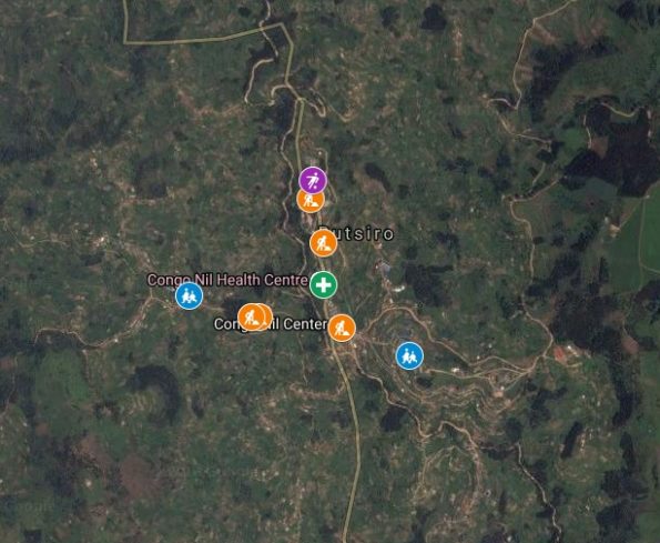
This blog post aims to explore the surface of geography, mapping, inclusion and where the common linkages can be. It will use some maps, some images and present some questions. But let’s start with perspectives that are relevant for a variety of aspects. Let me show you the first perspective: a Google Maps image from the town Congo Nil in the district Rutsiro of Rwanda:
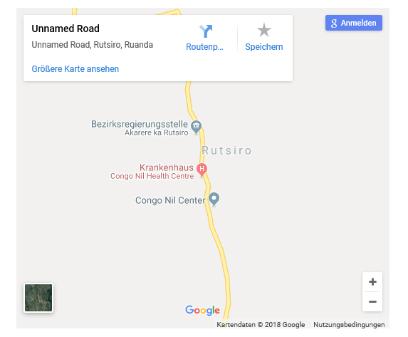
What you see here is what most people see of the proprietary Google Map. Most people will actually not think of anything related to disability, when regarding this map. Anything related to disability here is invisible. The map shows just a very schematic, not even a very exact, image of the geography and it contains not even any information that indicate that this place can be of any importance for persons with disabilities. But it is worth to take a moment and zoom in a bit closer to the satellite image that Google offers:
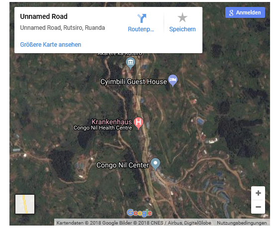
On this satellite image you see a bit clearer how the actual topography looks like and what might be there. If you focus your view on the lower right corner you can make out a number of blueish squares, which are are somehow linked by some ways or paths. By looking at the structures one can even identify some hills that might be there.
Getting into the maps
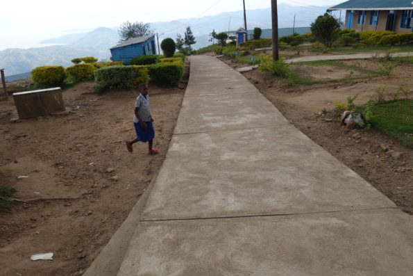
Now at least you are curious and you decide to go there to see, what you can find there. Actually the terrain with the blueish boxes is a school, made up of different buildings and ways of concrete linking them. This school has been supported by Handicap International to become more inclusive in terms of accessibility and training of teachers. Most of the buildings are accessible and even accessible sanitary spaces will be available.
So far so good, the school is there and families know that it is welcoming children with disabilities. But who else knows about it and how can this knowledge can be used in a better way? And how can development cooperation projects go further? Well, the first step would be to improve the information available on the maps, as in this OpenStreeMap:
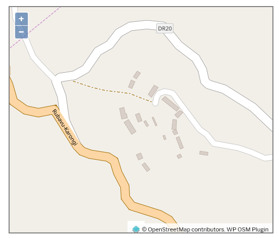
Detailed map of the school in Congo Nil
And from here on different perspectives can be imagined to move on further in order to bring this specific school into a larger context of Rwanda, to identify the places in the surrounding that can actually bring the rights of persons with disabilities to reality at community level, to engage with professionals in other services (e.g. hospitals, rehabilitation services, public administration), to bring in persons with disabilities for advocacy, bring in national actors that actually aim to improve access to services that will have a positive impact on the actual individuals and to collaboratively collect data as well as evidence that links up to the Sustainable Development Goals. This goes for the wider audience, but looking at implementing agencies there are also other aspects that can be of value to improve the project implementation.
International Development Non Government Organisations and Geographic Information Systems GIS
For us a employees of NGO there is a whole of other stuff interesting and important when we look at spatial information. We should look at how to tap into this source of information, collect it through collaboration with civil society, service providers and public authorities to make our actions more useful and to improve out interventions. How can this be done though? Just for starters I can give you some ideas:
- Partnerships: the first thing is to work in partnership. While we have a technical expertise we require still the local knowledge and have to leave the ownership with civil society and local actors. These are the experts who know the terrain, can articulate their demands, raise their questions and be the leader of this type of data collection.
- Places and information: We work in offices, schools and services that carry certain attributes. The most basic attributes are the address, the opening hours or the kind of service offered. Then there are more specific information for whom these services are, to what sector they are attached, if they are easily affordable or not and what you can expect from it. Looking at disability accessibility information is relevant maybe even the level of inclusion. For other service providers it might be interesting to understand the specificity of services (e.g. specific medical treatments, prosthesis, professional inclusion services). By itself each bit of information might appear unimportant but together it can create sufficient information to be relevant for some indicators linked to the SDGs.
- Make information on places available and meaningful: you know it yourself. Once you plan to go to a place to eat you are eager to get more knowledge beforehand. Do you get type of food you like, is the quality or price ok for you, have other people given reports and so on. It’s easy to check it up on one of the platforms online. But services for persons with disabilities in Rwanda? Making information available and sharing it will address different groups of persons: persons with disabilities themselves can discover that services exist close by, health facilities can identify for examples accessible schools to refer a visiting child there.
- Close the mapping gaps: In the countries of our interventions maps are incomplete. Looking at the example from the Rutsiro district in Rwanda we now have information on the services available but, just by looking at the maps, we do not yet know how people can get from A to B and what it means, if you have an impairment. A collaboration with the Missing Maps project can contribute to fill the gaps in OpenStreetMap.
- Improve and measure the impact of NGO projects: NGOs often train services and struggle to identify them. Afterwards they want to measure the impact. At this point spatial data can be helpful to target specific core services, to identify the champions and good practices. If this data collection is included in the baseline surveys the training impact can be followed up through the consideration of specific indicators, for example accessibility or inclusion.
- Make it OpenSource: Projects are good and innovative but they have an end point. Here OpenSource data and open platforms are important to share the collected information, invite others to improve the data further and to ensure the ownership by those most concerned persons from civil society, public administration and service providers.
We are currently shifting through data of about 250 services in 2 districts of Rwanda where a participative survey has been conducted with active involvement of Disabled People’s Organsiations (DPOs). It is a big amount of data that still have to be analysed and also to be made available, as soon as the concerned public authorities and services agreed to it. Also discussions with the national committee on Community Based Rehabilitation and national DPOs will have to be held.
Conclusive thoughts
While Geographic Information linked to inclusion and Systems to present it are fascinating it is important to look at it from the rights-based perspective. All persons in a country are right holders, the relevant human rights conventions describe the expected norms and states have to find ways to realize these rights. Through the SDGs a global framework exists that pushes for national action plans respecting human rights. And in that context we as NGOs cannot move without the national actors in order to leave the specific service behind for the grace of national policies and laws that – on the long-term – will ensure to leave no one behind.
So long….
[democracy id=”2″]